Hydrologic Analysis
The Hydrologic Analysis technical working group is charged with developing modeling tools and conducting hydrologic data analysis to support decision making for the Central Florida Water Initiative (CFWI) and to ensure work completed is technically defensible, understood by the initiative participants, and collaboratively developed.
The working group’s objectives are to provide necessary modeling tools and data analysis and work collaboratively with other CFWI staff to:
- Evaluate the current and future availability of sustainable groundwater
- Assess future municipal and agricultural water supply and management strategies
- Develop processes to assess the long-term effectiveness of the management strategies
- Support collaborative water supply planning
- Support future changes in regulations, as needed
Data and analysis tools
ECFT Model
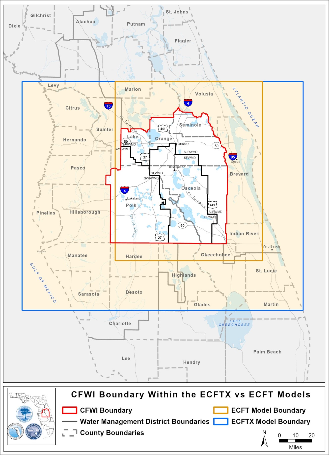
The East-Central Florida Transient (ECFT) groundwater model is a computer model of the hydrologic system in central Florida that was originally developed by scientists at the U. S. Geological Survey (USGS) but modified by the staff to meet project objectives. This model was first used to evaluate the effects from changes in groundwater withdrawals and other components of the water cycle on water levels in lakes, rivers, springs, and wetlands in support of the 2015 CFWI Regional Water Supply Plan (RWSP). Since the completion of this original work, the model has been expanded, calibrated, and updated as described below.
ECFTX Model v1.0
In preparation for the 2020 update of the RWSP, the Hydrologic Analysis staff expanded the model to provide a single groundwater model that encompasses the entire CFWI area. The expanded model (referred to as the ECFTX v1.0 model) extends from the Gulf of Mexico on the west to the Atlantic Ocean on the east and from southern Marion County in the north to the Highlands/Glades county line in the south. The model simulates three-dimensional groundwater flow in the surficial aquifer, intermediate aquifer/confining unit, Upper and Lower Floridan aquifers, and associated middle confining units.
Uses of the ECFTX model includes:
- Simulating effects of withdrawals on groundwater levels to evaluate the impacts of those withdrawals on lakes, rivers, springs, and wetlands
- Identifying the sustainable limits of groundwater withdrawals
- Evaluating future water supply options
Statistical analysis and other data analysis techniques using measured and simulated data were used to further investigate and quantify the factors affecting water levels in lakes, rivers, springs, and wetlands.
Independent Scientific Peer Review
As part of developing the ECFTX v1.0 model, the districts contracted with three expert modelers to conduct independent scientific peer review as the model was being developed. This enabled Hydrologic Analysis staff to incorporate significant comments before the model was completed and thereby provided the best possible modeling tool.
The Peer Review Report, Model Report and Model Files of the ECFTX v1.0 Model can be found below under the Archive.
ECFTX Model v2.0
The ECFTX v1.0 model, originally developed to support water supply planning decisions, was later updated to make the model a more suitable tool for regulatory decisions and improve the model performance in the areas where critical minimum flows and minimum water levels (MFLs) water bodies are located. A groundwater modeling team from the three water management districts (SJRWMD, SWFWMD and SFWMD) reviewed the model and identified an area within the CFWI portion of the domain where the original calibration could be improved. This area primarily included the Wekiva River springs groundwater contributing basin and Seminole County and was called the focus area. The recalibration effort was conducted only in the focus area with a goal to improve the model’s ability to better match observed water levels and spring flows. The recalibrated model is referred to as ECFTX v2.0. The ECFTX v2.0 model performance was considerably improved within the focus area and aquifer parameters were adjusted within a range consistent with the known hydrogeology in the region. Accordingly, the model-wide calibration performance was also improved as a result of the improvement in the focus area. Overall, the results of the recalibration provided greater confidence that ECFTX v2.0 could be considered an appropriate tool for assisting regulatory decisions, MFL evaluations, and future planning efforts. In addition, to facilitate water use permitting evaluations, Environmental Simulations, Inc. was retained by the three districts to develop a user-friendly regulatory tool by implementing Focus telescopic mesh refinement in Groundwater Vistas (a groundwater modeling package).
The ECFTX Model v2.0 was used to provide technical analysis in support of development of the 2025 CFWI RWSP.
Resources
Version 2.0
- ECFTX v2.0 Calibrated Model Files
- ECFTX v2.0 3sp Regulatory Tool (May 2024 update)
- ECFTX v2.0 7sp Regulatory Tool and Memo (February 2026 Update)
- Important: Prior to using the ECFTX Regulatory Tool, please check with district
regulatory staff at the number below to confirm this model is appropriate for your project. The ECFTX
regulatory tool will be updated regularly. Please ensure use of the latest version (posted above).
- SJRWMD Permitting Customer Service - (386)329-4570
- ECFTX v2.0 Model Report
Groundwater Availability
Groundwater Availability is the sustainable quantities of traditional groundwater sources available for water supply that can be used without causing unacceptable harm to the water resources and associated natural systems. A planning-level Groundwater Availability Assessment was conducted during the 2020 CFWI RWSP using the East Central Florida Transient Expanded (ECFTX or ECFTXv1.0) model. The number, location, and magnitude of impact on MFLs and MFL-related criteria, wetlands without MFLs, and groundwater quality, along with the quantities and spatial distribution of potential acres of stressed wetlands, were used to determine the potential extent of groundwater withdrawal impacts within the model domain.
Based on the 2020 CFWI RWSP groundwater availability, the CFWI Planning Area could potentially sustain up to 760 mgd of fresh groundwater withdrawals, and that local management strategies will be needed (e.g., wellfield optimization, aquifer recharge, natural system enhancement). The estimated groundwater availability is used by the Districts for planning purposes only and should not be viewed as regulatory constraints for specific Consumptive Use Permits/Water Use Permits (CUPs/WUPs). Decisions regarding CUPs/WUPs are made with additional information that is more site-specific and may consider opportunities for water resource development, management strategies, and mitigation of impacts. More information on the regulatory requirements associated with CFWI can be found here: CFWI Regulatory.
Archive
Version 1.0
- Peer Review Report of ECFTX v1.0 Model, March 31, 2020
- ECFTX v1.0 Model Report, February 2020
- ECFTX v1.0 Model Files
- ECFTX - 25% Pump Off
- ECFTX - 50% Pump Off
- ECFTX - 2003
- ECFTX - 2005
- ECFTX - Calib
- ECFTX - Ref 14
- ECFTX - Scen 25
- ECFTX - Scen 30
- ECFTX - Scen 35
- ECFTX - Scen 40
- East-Central Florida Transient (ECFT) Model Documentation August 29, 2014
- Hydrologic Analysis Team fact sheet
- Groundwater Availability Team fact sheet